Bicentennial Park nature trails

Bicentennial Park is an extensive skyline bushland park home to great walking tracks, the heritage-listed Mt Nelson Signal Station, a cafe, barbecue and beautiful picnic area.
Walks
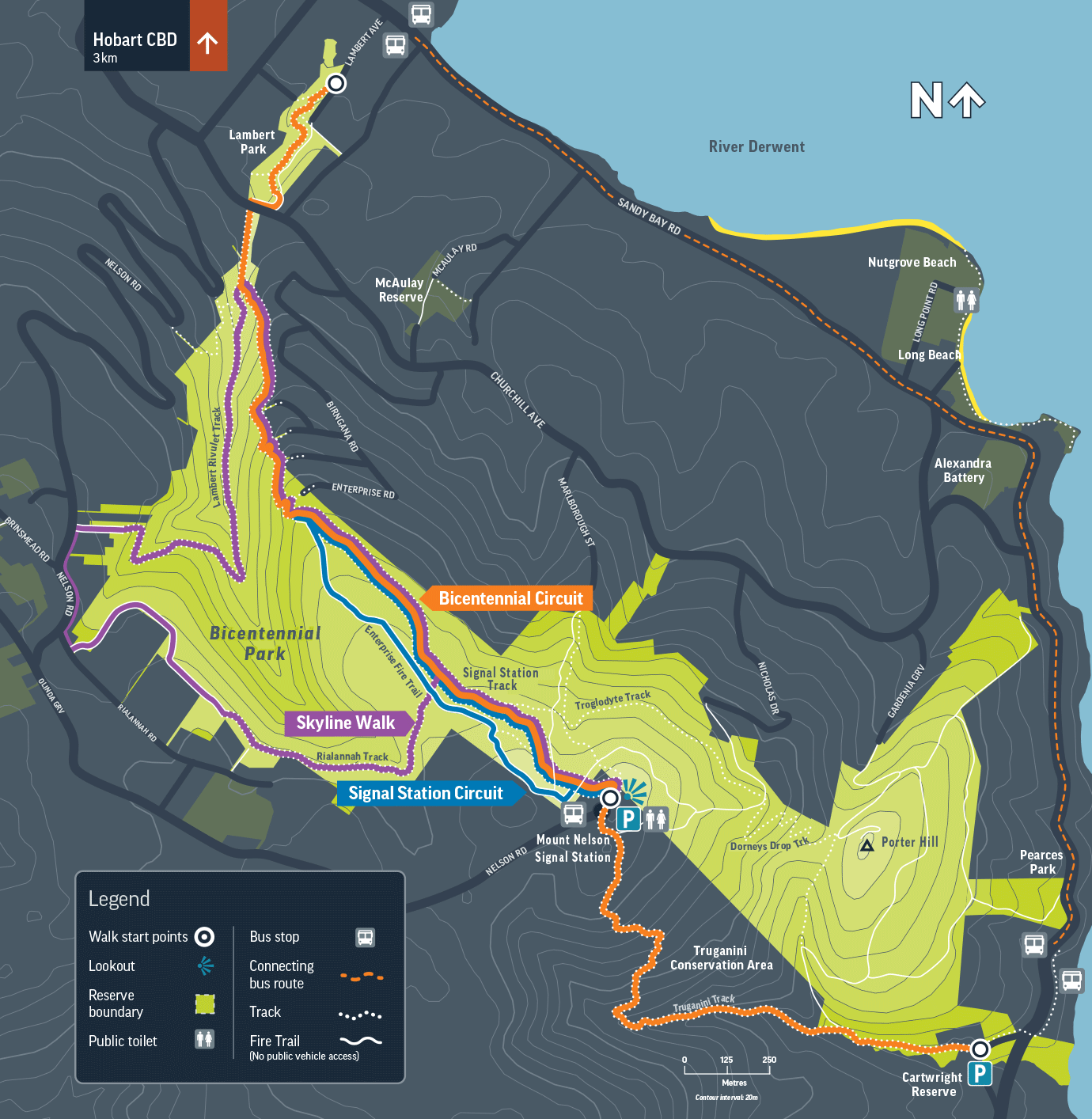
Signal Station Circuit
3.1 km loop – Easy
Wander through beautiful open forest, following Signal Station Track and returning along Enterprise Fire Trail.
Learn more on the Greater Hobart Trails website.
Skyline Walk
6.7 km loop – Moderate
Start at Mt Nelson Signal Station, following Signal Station Track to the foot bridge crossing Lambert Rivulet. Return up Lambert Rivulet Track, Nelson and Rialannah roads, then along Rialannah Track back to Signal Station Track.
Learn more on the Greater Hobart Trails website.
Bicentennial Circuit
5 km – Moderate
With parking and public transport options at both ends of the Bicentennial Circuit this is a great walk for anyone keen to explore Bicentennial Park and nearby Truganini Conservation Area. Start from either Lambert Avenue or the entrance to Cartwright Reserve, stopping for a picnic or lunch near the Signal Station.
Map

Download the map(PNG, 267KB)
Getting there
Mt Nelson Signal Station is a 10-15 minute drive from Hobart's city centre. Metro bus route 458 runs from Hobart up to the Signal Station. Metro buses 426 and 429 from Hobart stop on Sandy Bay Road, a short walk from the Lambert Park and Cartwright Reserve entrances to Bicentennial Park.
What to do
The Signal Station is open to the public and offers a fascinating insight into communication, maritime safety and Tasmania's colonial past.
Recreational tracks offer a variety of experiences ranging from wet gully forests where old blue gums tower over the creekline through to dry grassy forests on the ridgeline leading to the Mt Nelson Signal Station.
What to see
Be delighted by the park's native birds, including yellow wattlebirds, eastern spinebills and the endangered swift parrot.
Look for eastern barred bandicoots at dusk and dawn in open grassy areas. These creatures leave small, conical-shaped holes in the ground where they have been digging for bugs and grubs using their small claws and long snouts.
Nearby Truganini Conservation Area holds cultural significance as part of the traditional lands of the Tasmanian Aboriginal people, the Palawa. It is a short walk from the Mt Nelson Signal Station and home to the Truganini memorial, dedicated to the Tasmanian Aboriginal woman who played a significant role in the history of the region and the Palawa.
Signals from the past
Once part of a chain of signal stations that linked Hobart Town with Port Arthur, Mt Nelson Signal Station sits on the slopes of Mt Nelson and overlooks the River Derwent and Storm Bay.
It was established in the early 19th century to provide critical communication between Hobart and ships in the River Derwent and Storm Bay.
In the era before modern technology, communication with ships at sea was vital for maritime safety. The Signal Station used a system of flags to relay messages to and from ships approaching the port of Hobart. It played a crucial role in guiding ships through the often treacherous waters of the River Derwent, helping them navigate safely to their berths.
Download the brochure(PDF, 896KB)